google-site-verification: google1c6a56b8b78b1d8d.html Adena Hopewell Mound Builders in the Ohio Valley: mounds
Showing posts with label mounds. Show all posts

Thursday, February 13, 2014

Ashland County, Ohio Burial Mounds And Earthworks

Ashland County, Ohio Burial Mounds And Earthworks

Archaeological Map of the Burial Mounds and Earthworks in Ashland County, Ohio

ASHLAND COUNTY. 

Ashland county is remarkable among the northern counties 
of the state for the comparatively large number of earthen en- 
closures it contains. Most of these enlosures are quite small, and 
are both the circular and elliptical, and the rectangular type. 
Green township in particular is rich in these enclosures, while 
Mohican township also contains a number.


 The abundance of earthworks in southern Ashland County 
possibly may be due in part to the fact that the Great Trail passed 
through this section, crossing the headwaters of the Mohican river 
and the numerous streams tributary thereto. Numerous burials, 
old village sites, etc., together with the many stone implements 
found show that southern Ashland county was a scene of consider- 
able activity in aboriginal times. 

Wednesday, January 22, 2014

Scioto County, Ohio Archaeological Atlas

Scioto County, Ohio Archaeological Atlas
Mounds and earthwork locations in Scioto County, Ohio


Wednesday, May 15, 2013

Prehistoric Stone Cairns Near Arlington, Missouri


STONE CAIRNS AT SUGAR TREE CAMP , 
PLATE 13 a, Cairn six miles north of Arlington, Mo

Six miles north of Arlington is a clubhouse known as Sugar Tree Camp. A short distance from the building is a high vertical cliff rising almost directly from the Gasconade. The top of this cliff, near the front, is of solid rock, almost bare of timber or brush, and in a row along it close to the edge are seven cairns, all now so defaced that any attempt at investigation is useless. The smallest, at one end of the row, is of the common circular form, about 12 feet in diameter. Three others seem to be of the same type; but their appearance may be due to their destruction. One is shown in plate [41]13, a. The other three are walled vaults. The largest, at the other end of the row, was built up like a foundation wall of sandstone slabs. It is rectangular in form, measuring on the outside 16 by 28 feet. All the walls are more or less destroyed; the small portion of one remaining is shown in plate 13, b. Two "walled-up graves" reported on the first ridge north of Sugar Tree Camp, and one reported on the first ridge south, never existed. There is a small cairn on a high peak half a mile east of the camp.


PLATE 13 b, Walled grave six miles north of Arlington, Mo.
a Front b Profile.


Monday, November 26, 2012

Archaeology Map of the Mound Builders Works in Ohio

Archaeology Map of The Mound Builders Works in Ohio

Coming down to a smaller scope of territory, can it be shown that in the case of any one state the early Indian mound builders occupied the portions most heavily populated today? It has been said that, in Ohio, four counties contain evidence of having been the scenes of special activity on the part of the earliest inhabitants: Butler, Licking, Ross, and Franklin. These are interior counties (at a distance from the Ohio and Lake Erie) and, of the remaining sixty-three interior counties in the state, only seven exceeded these four in population in 1880—when the cities had not so largely robbed the country districts of their population as now. Thus the aborigines seem to have been busiest where we have been busiest in the last half of the nineteenth century.


                 Map showing the location of the mound builders works in ohio


Over 200 Burial Mound and Earthwork Sites Photographed and Directions Listed

Thursday, March 8, 2012

Adena Henge or Sun Temple is Discovered in Chillicothe, Ohio

 Adena Mound Builders Henge is Discovered in Chillicothe


Adena or Beaker People Henge in England. A "henge" is defined by a circular earthwork with an outer wall and interior ditch that is usually breached by a gateway that is aligned to a solar event. 


   A 2500 year old earthwork called a henge that was an earthen temple dedicated to the Sun god has been located in Chillicothe, Ohio.  Archaeologist at the Hopewell Culture National Park in Chillicothe were clueless of its existence, despite being literally in their back yard.  

   The henge in Chillicothe appears to be the standard size of this type that is 210 feet in diameter and 660 feet in circumference.  The surrounding ditch would have been 30 feet wide.  The best preserved of these henge types is at Mounds State Park.


This is the henge located at Mounds State Park in Anderson, Indiana. The henge at Chillicothe, Ohio is the same size.  Note the burial mound in the center of the middle platform.  At Mounds State Park this henge aligned with the adjoining works to align to the Summer and Winter Solstices.  It was later destroyed by Indiana University archaeologists who were completely ignorant to its importance as a solar marker.


Aerial photo of the Adena Sun Temple Henge in Chillicothe, Ohio.  It appears to be aligned to the Summer Solstice sunrise.  Also note, the dot in the middle of the central platform shows that a burial mound was in the center.  Another Henge was opposite this one, but is only faintly visible.  What appears to be a sacred via is also visible extending from the north portion of the gateway to the henge.


Another  Adena henge group is located in Cambridge City Indiana.  It, like the Adena henge in Chillicothe, Ohio has been plowed for many years.  This henge is the same size as Anderson and presumably Chillicothe.


Despite being plowed for years the Cambridge City, Indiana Adena henge is still visible in this field. It  is presumed that the Adena Henge in Chllicothe will look very similar to this. 


Wednesday, February 8, 2012

Ancient Indian Effigies at Mayville Wisconsin

Ancient Indian Effigies at Mayville Wisconsin


There are various interesting localities of ancient works in the vicinity of Mayville, as will be seen on Plate. The most extended of these is on the northwest quarter of section eighteen, township twelve, range seventeen, two miles northeast of the village. This group is shown on  It comprises thirty-five mounds of various forms, and occupies a nearly level strip between the base of a large ridge1 and brook.
1 On Plate I have endeavored to represent these diluvial ridges, and to show how they give direction to the water-courses. It would be a matter of much interest to the geologist to determine their extent and exact nature, with the view of ascertaining, if possible, their origin. But such an investigation would be out of place in this memoir.

We found here one of the largest and most regular turtle-mounds we had yet seen, and three or four of the quadruped form, one of which is represented on an enlarged scale on . The two crosses are directed towards the northeast, while most of the other forms have an opposite direction. Their arms are seldom at right angles with the body, nor are the two parts of the body or trunk in the same line. The head is always largest, highest, and nearly rectangular in] form. Their height corresponds with that of the other figures, it being usually from two to four feet. If these crosses are to be deemed evidence of the former existence of Christianity on this continent (as some have inferred), we may, with almost equal propriety, assert that Mohammedanism was associated with it, and, as proof:, refer to the mound or ridge here represented in the form of a crescent.
Three mounds, near the north end of the group, are cleft at the extremity, like that noticed at Burlington. One of them might be supposed to represent a fish, and, as the finny tribe must have afforded a principal source of subsistence to the builders, it would not be surprising if they should include them in the list of animals to be thus depicted. In that case the cleft extremity should be considered as a forked tail, rather than an open mouth. The general direction of the other figures would naturally suggest the same thing, at least in this locality.
In a cultivated field, near these works, were traces of other mounds, whose nature we could not determine; they were too far gone to be restored.
Half a mile east of this extensive group is a smaller cluster, consisting of two animals and two oblong mounds. They were discovered by the engineer party in the survey of the Valley Railroad, who reported the animals as resembling the horse. Mr. Logan Crawford, Deputy Surveyor of Dodge county, made a survey and drawing of one, given on, which, as will be seen, has but little resemblance to a horse. It was, without doubt, constructed, by men who had never seen or heard of such an animal, being long before its introduction upon the American continent.
The two figures at this place are almost exactly alike, and Mr. Crawford’s outline may be relied upon as correct. The dimensions were ascertained by running a line over the mound lengthwise, and then measuring at right angles from this line to thirty-six of the most prominent points in the outline. The height on the shoulders and fore-part of the body is about two and a half feet. The legs, tail, head, and neck, are not more than one foot high. Its whole length is one hundred and twenty-four feet.
Directly north of Mayville (on the northeast quarter of section fourteen, township twelve, range sixteen), on the eastern declivity, and near the base of a ridge, I saw some traces of ancient cultivation, in the form of garden-beds, with intermediate paths. In one place, where the beds were examined, they are one hundred feet long, and had a uniform breadth of six feet, with a direction nearly east and west. The depressions or walks between the beds were about eight inches deep and fifteen inches wide.
The next group of mounds noticed was at the northern extremity of a ridge near the lower dam and mills (northwest quarter of section fourteen). There were five elevations of the circular form, three of them with a projecting ridge, gradually tapering to the extremity, being of the kind called "tadpoles.”1 There are also two of the lizard form, the tail of one being in contact with the head of the other.
1 This form (see Fig. 18, p. 51), may possibly have been intended to represent the gourd, an ancient American plant, doubtless much used by the mound-builders.


On the adjoining tract (northeast quarter of section fifteen), are some round mounds; among them two of larger dimensions than usual, being from twelve to fourteen feet in height, and from sixty-five to seventy feet in diameter.
These several groups form a regular row, from east to west, a little north of Mayville. There is a similar arrangement at about the same distance south of the village, commencing at a group of three mounds near the centre of section twenty-six, which were very accurately surveyed and delineated by Mr. Crawford —the cross, as usual, with a direction opposite to that of the other figures, of which the central one is doubtless intended to represent the trunk and arms of the human body. The trunk is two feet high, the arms and shoulders one foot. The animal-shaped figure is brought too near this man on the plate (being ninety feet distant). It differs from most others of similar configuration in its slender form, rounded head, and recurved caudal extremity. The body is for most of its length two and a half feet high; the legs, head, and tail are one foot and a half high; but the tail gradually slopes down to about six inches at the extremity.

Sunday, November 13, 2011

Your Guide to Ancient Adena Hopewell Earthworks at Marietta, Ohio

Your Guide to Ancient Adena Hopewell Earthworks at Marietta, Ohio


   A remarkable group of works was among the earliest noticed by Western explorers. It was described by Harte as early as 1791; and a further account was presented in "Harris's Tour," published in 1805, in which an imperfect birds-eye view was also given. Since that period various descriptions have appeared in print; and a number of plans, differing materially in their details, have been published. It is of so much importance, however, and has been the basis of so much speculation, that it is time an accurate map and a careful description should be placed before the public. Such a map and such a description it is here aimed to present.
      The works occupy the high, sandy plain, at the junction of the Muskingum and Ohio rivers. This plain is from eighty to one hundred feet above the bed of the river, and from forty to sixty above the bottom lands of the Muskingum. Its outlines are shown on the map. It is about three fourths of a mile long, by half a mile in width; is bounded on the side next the hills by ravines, formed by streams, and terminates on the side next the river in an abrupt bank, resting upon the recent alluvions. The topography of the plain and adjacent country is minutely represented on this map.

     The works consist of two irregular squares, (one containing forty acres area, the other about twenty acres,) in connection with a graded or covered way and sundry mounds and truncated pyramids, the relative positions of which are shown in the plan. The town of Marietta is laid out over them; and, in the progress of improvement, the walls have been considerably reduced and otherwise much obliterated; yet the outlines of the entire works may still be traced. The walls of the principal square, where they remain undisturbed, are now between five and six feet high by twenty or thirty feet base; those of the smaller enclosure are somewhat less. The entrances or gateways at the sides of the latter are each covered by a small mound placed interior to the embankment; at the corners the gateways are in line with it. The larger work is destitute of this feature, unless we class as such an interior crescent wall covering the entrance at its southern angle.


The city library sits atop the smaller platform mound


Within the larger enclosure are four elevated squares or truncated pyramids of earth, which, from their resemblance to similar erections in Mexico and Central America, merit a particular notice. Three of these have graded passages or avenues of ascent to their tops. The principal one is marked A in the plan, and an engraving more clearly illustrating its features is herewith presented, Fig. 17. It is one hundred and eighty-eight feet long by one hundred and thirty-two wide, and ten high. Midway upon each of its sides are graded ascents, rendering easy the passage to its top. These grades are twenty-five feet wide and sixty feet long. The next in size is marked B in the plan, and is one hundred and fifty feet long by one hundred and twenty wide, and eight feet high. It has three graded passages to its top, viz. upon the north, west, and east. Those at the sides are placed somewhat to the north of the centre of the elevation. Upon the south side there is a recess or hollow way, instead of a glacis, fifty feet long by twenty wide. This elevation is placed upon an easy swell or ridge of land, and occupies the most conspicuous position within the enclosure, every part of which is commanded from its summit. A few feet distant from the northern glacis, is a small conical mound, surrounded with shallow excavations, from which the earth for its construction, and, perhaps, for the construction in part of the pyramidal structure, was taken. To the right of the elevation, and near the eastern angle of the enclosure, is a smaller elevation one hundred and twenty feet long, fifty broad, and six feet high. It had graded ascents at its ends, similar in all respects to those just described. It is now much obliterated. Near the northern angle of the work is another elevation, not distinctly marked. The two larger squares are covered with a close turf, and still preserve their symmetry. Indeed, no erections of earth alone could surpass them in regularity. They are perfectly level on the top, except where some uprooted tree has displaced the earth.


    There is a passage or gateway one hundred and fifty feet wide, in the middle of the left wall of this enclosure, on the side next the Muskingum. Leading from it towards the river, and at right angles to the embankment, is the "Sacra Via," a graded or covered way of singular construction. It is six hundred and eighty feet long by one hundred and fifty wide between the banks, and consists of an excavated passage descending regularly from the plain, upon which the works just described are situated, to the alluvions of the river. The earth, in part at least, is thrown outward upon either side, forming embankments from eight to ten feet in height. The center of the excavated way is slightly raised and rounded, after the manner of the paved streets of modern cities, The cross-section g h exhibits this feature. This section is constructed from measurements taken at a point midway between the top and base of the grade. Measured between the summits of the banks, the width of the way is two hundred and thirty feet. At the base of the grade, the walls upon the interior are twenty feet high. From this point there is a slight descent, for the distance of several hundred feet, to the bank of the river, which is here thirty-five or forty feet in height. It has been conjectured by some, that the river flowed immediately at the foot of this way at the time of its construction. This is, however, mere conjecture, unsupported by evidence. If admitted, it would give to this monument an antiquity greatly superior to that of the pyramids, unless the deepening of our river channels has been infinitely more rapid in times past, than at present. But one fact favors the conjecture, and that is the entire absence of remains of antiquity upon the beautiful terraces to which this graded passage leads. They may nevertheless have been once as thickly populated as they now are; and this passage may have been the grand avenue leading to the sacred plain above, through which assemblies and processions passed, in the solemn observances of a mysterious worship.


Marietta Mound encircled by a deep ditch was measured at 215 feet in diameter.  Identical measurements are found at Mounds State Park in Anderson Indiana and at New Castle Indiana.

    To the south of the smaller enclosure is a finely formed truncated mound, (a view of which is given in a subsequent Plate,) thirty feet high, and surrounded by a circular wall, constituting a perfect ellipse, the transverse and conjugate diameters of which are two hundred and thirty feet, and two hundred and fifteen feet respectively.This beautiful monument is now enclosed in the public cemetery, and is carefully guarded from encroachment. A flight of steps ascends to its summit, on which seats are disposed, and from which a beautiful prospect is commanded. In the vicinity occur several fragmentary walls, as shown in the map.

Tuesday, September 27, 2011

An Archaeological Survey of Adena Indian Burial Mounds and Earthworks in Wayne County, Indiana

An Archaeological Survey of Indian Burial Mounds and Earthworks in Wayne County, Indiana


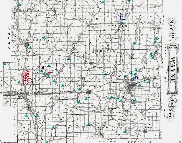
A map showing the locations of burial mounds and earthworks in Wayne County, Indiana

Eighth Annual Report of the Geological Survey of Indiana, 1876
      The high table-lands of this county, and its deep canon-like river valleys, afforded the Mound Builders favorable sites for their settlements, and we constantly find the remains of a number of large and interesting earthworks and a great many mounds scattered along the bluffs of the streams. Prof. J.C. MacPherson, county superintendent of schools of Wayne County, has kindly furnished me with a sketch of these ancient works, and as he has given considerable attention to the study of archaeology, his report is a very valuable acquisition to our knowledge on this subject, and I take pleasure in presenting it to the public.

Observations on the Prehistoric Earthworks of Wayne County, Indiana”
     The surface of Wayne County presents many evidences of occupancy by the Mound Builders. Mounds are found in all parts of the county-situated on the uplands and along the courses of the streams. The plowshare has leveled many, and some have been removed in opening roads to the material used in making brick. Twenty-five mounds have been located on a map of the county prepared in connection with the geological report.

The works in the county seem to be a continuation southward from the works along White River in Randolph County, and follow the branches of the White Water. Perhaps, when all the works located in this part of the Ohio Valley are mapped, some systematic arrangement may be discovered.

Three miles north from Fountain City (formerly called Newport), on a rise overlooking the wooded valley of Noland’s fork, is a mound seventy-five feet in diameter, (section 19, township 18, range 15 east).


A slight undulation in this field still marks the site of this burial mound.  

Another is on the farm of Daniel Hough, adjoining Fountain City. A third is said to have been removed in making the principal street of that town.

One mile northeast from Fountain City, on level ground, between Noland’s fork and a small tributary-Buck run-is an embankment enclosing eleven acres. The figure (Plate C) of this earthwork is a square with curved corners. The length on the inside of the embankment is 780 feet. The embankment has been plowed over for years, yet can be plainly traced. A gateway is discernible on the west side, and hollows are found in the vicinity, which some suppose were made by the builders when collecting material for the embankment. Since the accompanying map was made, a more careful survey has discovered the fact that the direction of the embankment is not due north and south, but at an angle, with the west side nearly parallel with the road.


Making the correction stated above about the position of the earthwork, if it was parallel to the road the gateway would be aligned to the summer solstice sunset and would again align to the west on the winter solstice sunrise.   


Undulations in this field are the only remnants of the once massive 50 feet wide earthen wall that enclosed this sacred temple. I have a LIDAR image of this fort where you can see the wall perfectly. https://adenahopewellmoundbuildersohiovalley.blogspot.com/2019/03/wayne-county-indiana-adena-square.html


A large mound stood two miles north from Chester (Section 4, Township 14, and Range 1 west). The greater part was removed in making the Arba road. A copper ring was found therein, and is now in the collection at Earlham College. (Judge N.R. Overman informs me that four copper bracelets were found. He has one in his cabinet. He also has three flint implements taken from this mound.)

Several mounds are situated in the neighborhood of Middleboro. Some have been opened, but no contents worthy of notice have been obtained.

One mile north from Richmond, on the Hoover farm, and in the vicinity, several small mounds were located. In one, when removed, was found a copper ornament.


The map shows two burial mounds and a square enclosure within the city limits of Richmond


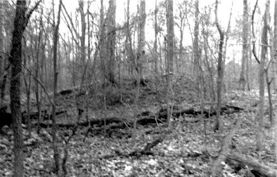
One of the burial mounds near the square enclosure is still visible in some dense thickets. The mound is unique in that a graded way leads to second terrace below.

A mound near Earlham College was opened by President Moore and the usual contents of mounds found-pieces of pottery, ashes, and other evidences of fire.

On the J.C. Ratliff farm a mound was opened, and some small articles, which were at first supposed to be beads, but are now thought to be parched corn, found therein. L.B. Case, of Richmond, has some grains of corn, which were found in a jar some distance below the surface of the ground, in the vicinity of that place.

A large mound south from the town of Centreville was deemed of sufficient note to be marked upon an early map of the State, but has since been destroyed.

In the southwestern part of Boston Township is a mound hidden away in a “hollow”; and one formerly stood south from Richmond near the Boston pike.


A small burial mound located in a holler next to a small creek.  Small burial mounds like this that are tucked away far from the road are in the greatest danger of being destroyed by University archaeologists. 

Traces of a mound are to be seen on the farm of James W. Martindale, adjoining Washington. This mound was opened in early times, and charcoal found near the original surface of the ground. A great quantity of arrowheads has been found around a spring (long since dry) near this mound.

A circular embankment was found near Green’s fork, east from Jacksonburg, twenty-five feet in diameter. It was long since plowed down.

Two mounds are to be seen a short distance northwest from Jacksonburg.

Overlooking Martindale’s creek in Jefferson Township (section 18, township 17 north, range 13 east,) is a mound. Also two in the bottom land along West River, at Hagerstown.

Two miles southeast from Milton (section 6, township 15, range 13 east,) is a beautiful mound, fifteen feet in diameter. Forest trees are still standing upon it; also a stump measuring two feet across.


Headwaters to creeks were Sacred Grounds to the early mound builders.


The burial mound is still visible in this field, but it is now under cultivation.  It appears that this mound is of natural origin, but was used for burials.  

Near the county line, about one-mile north of Waterloo, Fayette County, is a mound upon high ground, and about a mile to the southeast, in Fayette County, is a curiously shaped.


This mound is visible across the road from the holler.  According to the landowner it was much more conical years ago before being plowed.


The most notable mounds (Plates A and B) in Wayne County are located on the left bank of the west branch of the White Water River, one and a quarter miles north of Cambridge City. They consist of a series of circular embankments, continued over half a mile of ground.


Earthwork cox near Cambridge City, Indiana

The south circle (Plate A) is in the best state of preservation. The embankment was made of the earth taken from the trench, which is on the inside of the embankment. Within, the ground has been made to slope gently from the center to the bottom of the trench, except to the east, where there was left a roadway leading from the center through a gateway in the embankment to the level ground beyond. The embankment is four feet above the surface of the field, and seven feet above the bottom of the trench, and wide enough on the top to allow two carriages to pass each other. The gateway is one rod wide. This circle is made of gravelly soil, while the north circle is composed of a loam, and has yielded more to the destroying influence of plowing.  It is not as symmetrical as the other, being more oval in outline.


Two large henges of the Cambridge City earthwork complex.  The north henge is aligned to the summer solstice sunrise, and would align again on the winter solstice sunset.


Henge complexes at Mounds State Park in Anderson, New Castle Indiana, and Athens, Ohio all contained 8 works in the group. From the previous map, the Indiana Geological Survey placed 7 north along the river and the two main henges.  In this aerial photo the 8th earthwork is revealed next to the southern henges northwest side.  A similar, smaller circle also occurs at Mounds State Park in Anderson, Indiana. I have a LIDAR image of this site that reveals a new revelation about the north work that was not a circle but a Panuriform.  To see the photo https://adenahopewellmoundbuildersohiovalley.blogspot.com/2019/04/wayne-county-indiana-panduriform-henge.html


Despite being plowed for years the central platform and exterior ditches are still visible of the Southern Henge. The gateway also still visible and marking the yearly equinoxes as it has done for the last 2000 years.

The class of works to which these belong is described in “Ancient Monuments of the Mississippi Valley,” page 47, and are denominated “Sacred Enclosures.”

These two circles on Plate A, are about fifteen rods apart, and about the same distance from the bluff of the stream. In the bluff, equally distant from both the circles, is a passageway cut from the top of the bluff to low ground bordering the water, some twelve feet below. This cut is evidently not a water-wash, for along the sides can be seen the earth which was removed in making it thrown up as dirt is thrown up along the sides of a ditch.


This "cut" is still visible between the two henges that leads on a gradual descent to a small creek that runs to the west of the earthworks.  It is evidence of an important concept at most earthworks sites that will have elements of both the Sky Father (sun) and the Earth Mother (creek)

The bluff here spoken of is the edge of the first terrace. The rounded margin of the second terrace can be seen a quarter of a mile to the east.

Several hundred feet north from the second of the above-described circles is a group of five small circles (Plate B). With one exception these are about sixty feet in diameter, and are now from one to two feet high. The circle numbered 3, on Plate B, is at the point of a tongue of higher ground, and affords an outlook over the other works.  The embankment of the largest work in this group (numbered 7) can not be traced on the south, that part being in a field which has long been cultivated. Trees of large size were, until recently, standing upon the embankments of these works.

Burial places and remains have been found in various localities within the county. A number of years ago, in removing the gravel from a bank in the northwest part of Jefferson Township, nine feet below the surface, eight skeletons were discovered. They had been buried in an upright position. These bones were gathered together by the workmen and reburied in a common grave. In constructing the Valley Railroad from Hagerstown to Cambridge City, human remains were exhumed; also some at the latter place.

O. Beeson communicated to the local papers some twelve years ago an account of the discovery of a burial place in the extreme southwest corner of the county. Many skeletons were found in a gravel bank, some having been placed in a sitting posture and some with the head downward.

Recently some twenty or more skeletons were unearthed in a gravel pit on George Jordan’s farm, about two miles northwest from Economy. These bodies seem to have been buried in graves a few feet apart, and six feet below the surface. Some of them were in a sitting position, while others were in various positions.

The discovery of a human skeleton in a mound on the bank of White Water, near Richmond, many years ago, was the occasion for the following lines from the pen of the late John Finley; author of the “Hoosier’s Nest,” and other poems, and once Mayor of Richmond.

“Year after year its course has sped,
Age after age has passed away,
And generations born and dead,
Have mingled with their kindred clay,
Since this rude pile, to memory dear,
Was watered by affection’s tear.

* * * * * * * * * *

“No legend tells thy hidden tale,
Thou relic of a race unknown!
Oblivion’s deepest, darkest veil
Around thy history is thrown;
Fate, with arbitrary hand,
Inscribed thy story on the sand.”

Stone and flint implements were formerly found in great numbers in this region. Wayne County, like the rest of our State, has suffered in being robbed by collectors and traffickers, who have carried away many specimens to grace the museums of other states. But recently more interest has been manifested in the subject of archaeology, and the collection at Earlham College, and several private collections, are beginning to assume interesting proportions.

Setzler’s Survey”, Indiana Historical Society
The Indiana Historical Society is in leauge with the university archaeologists and the DNR to destroy every mound in Indiana. Despite a historical legacy than spans thousands of years the Indiana Historical Society has not saved, preserved or even noted any of these antiquities as historic sites. They have given millions of dollars to universities to desecrate burial mounds across the State.
The following list is a good example of the mindless destruction done to Indiana's antiquities by the Indiana Historical Society.

These are mounds in his report in addition to mounds reported by McPherson.

1.) Schroeder Mound. On the east bank of the Green Fork. Diameter of mound twelve feet, six inches. Located in the southeast one quarter of Section 21, Green Township.


Very little remains of the Schroeder mound after Setzler and the Indiana Historical Society were done with it.

*If mound found in frac.-Section 19 of New Garden Township, mound was originally forty feet in diameter and three feet high.

2.) Teetor Mound. Located one mile east of Hagerstown on Highway 38. Originally the mound was 43 feet in diameter and eight feet high.  Southeast quarter of Section 23, Jefferson Township.

3.) Wolford Mound. Measured 45” in diameter and five and half feet high. One-quarter mild northeast of the circular earthwork. Mound’s location was the northeast one quarter of Section 15, Jefferson Township.

4.) This mound was used by surveyors as a base for survey measurements. It was described as being 45 feet in diameter and nine feet high. Located in the northwest one quarter of Section 5, Jackson Township.

5.) Secrist Mound. Was located in a woods, one half mile southeast of Jacksonburgh. Mound was originally 42 feet in diameter and eight feet high. Located in the southwest one-quarter of Section 8, Harrison Township.

6.) Davis Mound. Near the edge of the east bank of the Green Fork stood a mound 43 feet in diameter and 5 feet high. Located in the northeast one quarter of Section 16, Harrison Township.

7.) No physical descriptions exist of two mounds located in the northeast one quarter of Section 6 and the northwest one quarter of Section 5, Harrison Township.

8.) In the northeast one quarter of Section 6 and the northwest one quarter of Section5, Harrison Township.

9.) Hodgins Mound. Original dimensions were thirty-nine feet north and south, forty-eight feet east and west and was three to four feet in height. Located in the southeast one quarter of Section 21, Wayne Township.


Burial mound is still visible on a table of high ground that descends into an aquifer. The mound is located within the city limits of Richmond.

10.) Richmond City Waterworks. Mound originally was thirty-five feet in diameter and nearly six feet high. Located in the northeast one quarter of Section 34, Wayne Township.


After an hour of clearing brush from the earthen heap, we were able to photograph the Waterworks mound.  It would be visible from the road if it were cleared.

11.) Mound once stood roughly 11,000 feet from the west bank of the East Fork of the Whitewater River in the northwest one quarter of Section 8, Wayne Township.

12.) One mile south of the City of Milton was a mound forty-nine feet in diameter and five feet high in the northwest one quarter of Section 11, Washington Township.

13.) A small mound was located in the northwest one quarter of Section 12, Washington Township.

14.) Doddridge Mound. Located on a sharp bend of Noland’s fork. Originally the mound was thirty-eight feet in diameter and three feet high in the southwest one quarter of Section 16, Washington Township.

15.) Robbins Mound. Mound used to be visible from the road that divides Section 17. Its size was forty-five feet east, west, and 35 feet north-south with a height of four feet. Location was the northwest one quarter of Section 17, Abington Township