google-site-verification: google1c6a56b8b78b1d8d.html Adena Hopewell Mound Builders in the Ohio Valley: mounds
Showing posts with label mounds. Show all posts

Sunday, October 12, 2014

Rare Early Photographs of the Newark, Ohio Earthworks

Rare Photographs of the Newark, Ohio Earthworks

Two photographs of the Newark, Ohio earthworks prior to the ceremonial center being converted in to a golf course. The Newark Earthworks are believed to have been constructed around 100 B.C. The Newark Earthworks demonstrate the knowledge of mathematics and geometry that was demonstrated in the construction of this ancient work.


The two photos featured are the circle and octagon in left portions of this map.  the Neark works also included the large henge and a square earthwork.


This photo shows the sacred via that connected the octagon and the circular earthwork.  This via nows serves as golf tee.


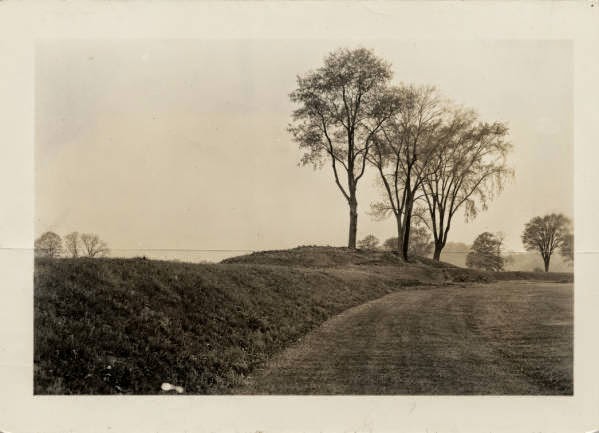
This is the southwest portion of the circle that features a mound and on the back end what appears to have been the beginning of two parallel walls of a sacred via.  

Monday, September 22, 2014

Excavation of the Circleville, Ohio Adena, Burial Mound

Excavation of the Circleville, Ohio Adena, Burial Mound


Near the center of the round fort was a tumulus of earth about 10 feet in height and several rods in diameter at its base. On its eastern side, and extending 6 rods from it, was a semicircular pavement composed of pebbles such as are now found in the bed of the Scioto River, from whence they appear to have been brought. The summit of this tumulus was nearly 30 feet in diameter, and there was a raised way to it, leading from the east, like a modern turnpike. The summit was level. The outline of the semicircular pavement and the walk is still discernible. The earth composing this mound was entirely removed several years since. The writer was present at its removal and carefully examined the contents. It contained—
1st. Two human skeletons, lying on what had been the original surface of the earth.
2d. A great quantity of arrow-heads, some of which were so large as to induce a belief that they were used as spear-heads.
3d. The handle either of a small sword or a huge knife, made of an elk’s horn. Around the end where the blade had been inserted was a ferule of silver, which, though black, was not much injured by time. Though the handle showed the hole where the blade had been inserted, yet no iron was found, but an oxyde remained of similar shape and size.
4th. Charcoal and wood ashes on which these articles lay, which were surrounded by several bricks very well burnt. The skeleton appeared to have been burned in a large and very hot fire, which had almost consumed the bones of the deceased. This skeleton was deposited a little to the south of the center of the tumulus; and about 20 feet to the north of it was another, with which were—
5th. A large mirrour about 3 feet in breadth and 1½ inches in thickness. This mirrour was of isinglass (mica membranacea), and on it—
6th. A plate of iron which had become an oxyde, but before it was disturbed by the spade resembled a plate of cast iron. The mirrour answered the purpose very well for which it was intended. This skeleton had also been burned like the former, and lay on charcoal and a considerable quantity of wood ashes. A part of the mirrour is in my possession, as well as a piece of brick taken from the spot at the time. The knife or sword handle was sent to Mr. Peal’s Museum, at Philadelphia.
To the southwest of this tumulus, about 40 rods from it, is another, more than 90 feet in height, which is shown on the plate representing these works. It stands on a large hill, which appears to be artificial. This must have been the common cemetery, as it contains an immense number of human skeletons of all sizes and ages. The skeletons are laid horizontally, with their heads generally towards the center and the feet towards the outside of the tumulus. A considerable part of this work still stands uninjured, except by time. In it have been found, besides these skeletons, stone axes and knives, and several ornaments, with holes through them, by means of which, with a cord passing through these perforations, they could be worn by their owners. On the south side of this tumulus, and not far from it, was a semicircular fosse, which, when I first saw it, was 6 feet deep. On opening it was discovered at the bottom a great quantity of human bones, which I am inclined to believe were the remains of those who had been slain in some great and destructive battle: first, because they belonged to persons who had attained their full size, whereas in the mound adjoining were found the skeletons of persons of all ages; and, secondly, they were here in the utmost confusion, as if buried in a hurry. May we not conjecture that they belonged to the people who resided in the town, and who were victorious in the engagement? Otherwise they would not have been thus honorably buried in the common cemetery.

Friday, August 22, 2014

Demoret Adena Burial Mound in Butler County, Ohio

Demoret Adena Burial Mound in Butler County, Ohio


The largest mound of this group must have been destroyed at some time, leaving this smaller mound of the group as the only one to survive the urban sprawl. It is situated next to a new home, however it has been left with thick underbrush and trees growing on it that make it difficult to see.
The Mound Builders, Archaeology of Butler County, Ohio, 1879:

On the farms of William Hogan and Charles Borger, section twenty-one, is group of mounds, six in number. A plan of these given in Fig. 56.
The largest is twenty-six feet high with a base eighty feet in diameter. The rest vary in height, ranging from three to eight feet. The illustration gives the relative sizes, positions and distances of the mounds composing the group. The group is situated on the highest point of land in the township, and from the summit of the largest mound a view of the surrounding country can be obtained. To the east, if the forest trees did not intervene, the city of Hamilton could be seen; while to the south it overlooks the Colerain Hills.
  Mr. L. Demoret looked up the history of and the stories concerning this mound, and writes as follows:
“About the year 1820 this mound was opened by a man named Young, assisted by the Keever brothers, in hopes of finding a treasure chest. They worked only during the hours of darkness, and in perfect silence, in the belief that the chest never could never be reached if a word was spoken while at work. A story was started, and believed by many, that the chest was finally discovered, when one of the diggers exclaimed: ‘I’ve got it at last!’ whereupon it slipped from his fingers and vanished, leaving a smell of brimstone in the air.
“The tunnel was started on the north side, about half way up the slope, and ran downwards at an angle of thirty-five degrees, for a distance of thirty feet, when the center was reached, from which point it was carried eastwardly several feet. It was stated at the time that the center of the mound gave the appearance of having been once a hut formed of leaning timbers to sustain the great weight of earth. Within this vault were found a stone back-wall, coals and ashes, and human bones.”

Sunday, August 17, 2014

Indiana Archaeologists Determine Hopewell Earthwork at Strawtown, Indiana is Oneoto Sioux

Indiana Archaeologists Determine Hopewell Earthwork at Strawtown, Indiana is Oneoto Sioux


The Srawtown henge is discernable from the circular elevated platform seen on the left encircled by a ditch with the outer wall also still visible. Despite being plowed for years what may be a gateway is evident on the southeast section. Traces of additional embankments were discovered several hundred yards south of the earthwork. The Strawtown earthwork is located on the high ground overlooking the White River as it bends to the south.
The larger size of this henge is comparable to others found at the Highbank Works at Chillicothe, Ohio and Yorktown, Indiana. The henges around Piqua Ohio also include a work 300 feet in diameter along with a spoked burial. A spoked burial was also discovered in Madison County Indiana near the works at Mounds State Park. IPFW archaeologist excavated parts of the earthwork and concluded that the artifacts they found were culturally affiliated with the Oneoto Sioux. Strawtown is the anchor to Indiana’s magical 50 miles that reveals by going back upriver to the east the circular henges at Mounds State Park, the henge in Delaware county, the large mound at Windsor and the Winchester works.  


Indiana Department of Geology and Natural History (Fourteenth Annual Report), 1884
But Strawtown has an antiquity evidently higher than the days of the Delaware Indians. The mound builders have left their footprints in this vicinity by the numerous relics of the Stone Age that have been picked up by the present inhabitants. A little west of the present village there is a burial mound about six feet high; it has been plowed over for a number of years, so that not only its height has been reduced, but its base rendered so indistinct that its diameter can not be accurately measured; it is, however, between seventy and eighty feet. It was opened in 1882 by Judge Overman, of Tipton, and four skeletons were found lying on the original surface of the ground, with their heads together and their feet directed to the cardinal points of the compass.
This type of 'spoked burial' is found throughout the Ohio Valley associated with both the Adena and Hopewell.

At a distance of 150 yards southeast of this mound is a circular embankment, now about three feet high, and twelve feet on the base.  The diameter of the circle, measured from the bottom of the ditch on each side, is 315 feet. There is a doubt as to what period this work should be referred. A tradition among the “old settlers” claims that the remains of palisades that once formed a stockade, were standing on the embankment when the early immigrants settled here. This tradition is strengthened by the fact that in 1810 a stockade was built by the Delaware Indians somewhere near this spot, as a protection against their Miami neighbors north of White River. Moreover, it was not the custom of the mound builders to make a ditch on the outside of their embankments. On the other hand, the regularity of the work, and the perfect form of the circle, is hardly compatible with the idea that this is the work of modern savages. It is possible that the circle dates back to the period of the mound builders, and that the Delaware’s took advantage of it to build their stockade on, and made the ditch to strengthen their palisades. The ditch was been filled, and the embankment reduced much by cultivation.

Saturday, August 16, 2014

Ancient Iroquois Burial Mound Located North of Fort Wayne, Indiana

Ancient Iroquois Burial Mound Located North of Fort Wayne, Indiana


This single mound located on the IPFW campus was originally built on a projecting upland formed at the confluence of Breckenridge creek and the St. Joseph River. A dam has flooded this area, leaving this mound partially submerged for most of the year. Photo is from, "The Nephilim Chronicles: A Travel Guide to the Ancient Ruins in the Ohio Valley.


The History of Allen County, Indiana, 1888:

Prehistoric Remains” by R. S. Robertson


Still further down the river, on the east side, at the mouth of Breckenridge Creek, is a single mound, which has not been opened except a slight excavation in its side, which developed the customary lumps of charcoal. This point is about four miles north of Ft. Wayne, and is the most southerly point in the county at which mounds and earthworks are known to exist.

Sunday, June 8, 2014

Winter Photographic Gallery of the Newark, Ohio Earthworks

Winter Photographic Gallery of the Newark, Ohio Earthworks

Newark, Ohio earthworks in the winter. Pics from "The Nephilim Chronicles: A Travel Guide to the Ancient Ruins in the Ohio Valley."

The best time to visit the Newark earthworks is the winter months when you can freely walk the grounds. 

Photo is taken from the gateway of the henge. In the summer months the ditch is overgrown and not visible.

This photo is looking in the opposite direction from the gateway of the henge that is aligned to the May 1st sunrise. On October 31st the sun will align with the gateway when the sun sets.

From the gateway the bird effigy is visible in the background.  The bird represented 'transition' this could have been for the people buried within the effigy or the transition from spring to summer and fall to winter.

This earthwork or sacred via goes from the henge to the square earthwork. See map above.

One of the 8 walls of the Octagon with one of the mounds guarding the gateway to the left.

From the walls of the Octagon, a smaller circle with a serpentine gateway is still well preserved. The circle was at the opening of the Hopewell Road that ran from this spot to Chillicothe, Ohio, 60 miles distant.

Two parallel earthworks connect the Octagon with the circular earthwork.

Circular earthwork attached to the Octagon.


Tuesday, May 27, 2014

Early Description of the Newark, Ohio Ancient Earthworks

Early Description of the Newark, Ohio Ancient Earthworks


The immediate vicinity of Newark seems to have been a sort of headquarters, or great central city. Newark, indeed, is built upon the ruins of the works of this mysterious people, many mounds having been leveled to make way for streets and buildings, and the city has extended into the Great works, of which a cut is here given. This drawing is taken from a survey by David Wyrick, in 1860, and gives a faithful outline of the Old Fort, and the connecting works within a radius of one mile. The outlying works are nearly obliterated, with the exception of some of the parallel lines and the Octagon fort and its connecting circle. The larger circle in the drawing marked "thirty acres," represents the most prominent and best preserved of all this series of works and is now owned and used by the Licking County Agricultural society; its preservation being thus assured. The portions of the cut represented by a square, and parts of the lines of an oblong, are nearly obliterated by the growth of the city of Newark in that direction. The octagon and circle marked respectively "fifty acres" and "thirty acres," have been partially subjected to the leveling processes. The whole plain between the South and Raccoon forks of Licking river, and covering an area of several square miles, bears traces of occupation by the "lost race." It is evident from the remains here found, that this section was densely populated, and the character of the works, too, bear out the assumption that this people passed through the different stages of existence that fall to the changing experience of nations at the present day. The following description of the Old Fort is probably the most accurate as to measurements and other particulars yet given, being the result of actual surveys made by Colonel Charles Whittle sey, of Cleveland, and Isaac Smucker, esq., of Newark : "The Old Fort is situated a mile and a half in a southwesterly direction from the court house in Newark, and belongs to the class of Mound Builders' works known as inclosures. It is not a true circle, the respective diameters being eleven hundred and fifty, and twelve hundred and fifty feet. Its banks, nearly a mile in length, were formed by throwing up the earth from the inside, which left a ditch of sloping sides, ten feet (in many places more) in depth, and ranges, in perpendicular height, measuring front bottom of ditch to top of bank, from twenty to thirty feet. This inclosure, which embraces within it about twenty-seven acres of land, was constructed on level ground, and the ditch above described was often seen, during the earlier decades of the present century, partially, and sometimes wholly, filled with water all around the circle. From some cause it has not held water of later years to any great extent. Viewed from the outside, the embankment does not rise more than ten to fifteen feet above the surface of the surrounding ground, but observed from its top, the eye taking in the depth of the ditch, it seems, of course, much higher, so as to correspond in height, at least, to the figures above given. "The Old Fort has an entrance or gateway, which is flanked by a high bank or parapet on either side of it, running outward forty yards. The gateway and parallel walls or parapets are on the eastern side, of the circle, and the ditch which follows it also extends to the termination of the parallel banks that cover the entrance. Mere the banks are highest; the parallel walls, as well as those which form the circle immediately adjoining them at the gateway, reaching, for a short distance, a perpendicular height of at least thirty feet, measuring from the bottom of the ditch, or twenty feet, measuring on the outside. The gateway or entrance measures seventy-five feet between the ditches or moats, and between the parapets or banks of earth that flank the entrance, one hundred and thirty feet around the circle, as well as upon the parallel walls at the     entrance. They are equal in size to those that are yet found on the outside of the inclosure and \\ within it and of the same varieties. Some of them measure ten feet in circumference and are still thrifty, giving no indications of decay. One of the largest trees that stood on this embankment was cut down in 1815, and its concentric circles showed that it had attained to the venerable age of over one hundred and fifty years.
     In the middle of the Old Fort is an elevation, evidently artificial, which never fails to attract the attention of the observing, and is generally designated as Eagle mound. It is full six feet high, and is in the form and shape of an eagle in flight, with wings outspread, measuring from tip to lip two hundred and forty feet, and from head to tail two hundred and ten feet, and is clearly of the effigy class of the works of the Mound Builders. It faces the entrance, and therefore lies in an east and west direction, its wings extending north and south. Excavations made many years ago into the center of this earthen figure, where the elevation is greatest, developed an altar built of stone, upon which were found ashes, charcoal and calcined bones, showing that it had been used for sacrificial purposes. "Many have held the opinion that the Old Fort was a military work, constructed for defence, but its location on a level plain, its symmetrical form and inside ditch, and the indications of the presence of fire, seen on the altar, and its sacrificial uses, so clearly suggested, all go to render this opinion to be erro neous, or, to say the least, one highly improbable. All the known facts pertaining to it go to raise the presumption that within this inclosure were conducted by Mound Buiders, the rites and ceremonies of their religion, they having manifestly been a religious and superstitious race, given to the practice of offering up human as well as animal sacrifices. "Others have believed that the Old Fort was the seat of government of the Mound Builders, and that their monarch resided here
    "It was in October. 1800, when Isaac Stadden. a pioneer settler in the Licking valley, discovered it. One of the most astonishing and incomprehensible things about this great earthwork is the ditch inside of it. This, as Mr. Smucker says, is yet ten feet deep, and is, probably, fifteen or twenty feet wide at the top. If it were not for the immense trees that yet stand on the embankment, one would be inclined to place the construction of this work within the last century, from the fact that other wise this ditch should have long since disappeared, having been filled, by the yearly drift of leaves, etc, to the surface of the ground. When the fact is considered that this ditch has stood in the midst of the forest for centuries, and has thus been a safe receptacle for the yearly fall of leaves that would naturally drift into it, that the storms of centuries have been washing its banks, that, as Mr. Smucker says, water once stood a good portion of the year in it, with its relaxing and dissolving tendencies, the absorbing questions are, how deep must this ditch have been at first, and what tools could the workmen have used to raise the dirt to such a height, and for what purpose was it constructed ; why, especially, was it made so deep? Supposing that from all the causes above     enumerated, the ditch had filled one inch per year for six hundred years; even that would give it a depth of fifty feet at first. It would seem more probable that it would fill five or six inches every year, instead of one inch; and it is thought these works are a thousand years old instead of six hundred. This being true, would make this ditch very much deeper, and only increases the mystery that already surrounds these works. Here is an opportunity for scientific investigation that should not he lost. A shaft sunk in the bottom of this ditch would probably reveal its original depth. The immensity of these works is truly wonderful and awe-inspiring. The stranger visiting them for the first time can only look and wonder. The pyramids of Egypt are counted among the "seven wonders of the world," but in what particular are they so much more wonderful than this earthwork? Both are equally mysterious and incomprehensible. The "Eagle Mound" in the center of this inclosure, is somewhat disappointing at first sight, and does not appear to have much resemblance to an eagle. It more resembles the shape and form of a honey-bee, and might more appropriately have been called the "Honey-Bee mound." The wings are not pointed, like those of a bird, but circular, like those of a bee, and the body is shaped much like that of the bee. Samuel Park, esq., thus writes concerning these works: •' Mr. Atwater says that many of the writers on these antiquities never saw the works themselves, or if they did. it was only from some public conveyance in hasty flight through the coun try; and consequently they know nothing about them, and their representations are not reliable. This, no doubt, in some instances is true. But those newspaper correspondents, and other persons seeking literary renown, are not the only persons chargeable with having arrived at conclusions, and published opinions, based upon observations quite too superficial. Mr. At water himself, with all his care, is not safe from this charge, for in his report on the antiquities of Licking county, though he made a personal survey of them, seems to have but little knowledge of their extent and diversity of character. He gives us very correct diagrams of a portion of the works in Cherry Valley, and speaks of one or two mounds, south of Newark, and some pits below Newark, and south of Licking river. These he calls the works in Licking county, while they constitute but a very small proportion of them.
   The mathematical skill manifest in the construction of some of these works, as well as the fine topographical engineering shown in the location of these signal mounds, indicate a pretty high degree of culture, for that age of the world, and. I think, conclusiw evidence that they were not erected by the ancestors of our native Indians, as it is not probable that they ever advanced bevond the hunter-grade of civilization in which we found them, while our Mound Builders must have been much in advance of this. These signal mounds are not always found on the highest hills, but where they will command the most complete view of the whole land, whether below or above their location, and where they can be seen by the greatest number of other mounds, by views through valleys, or between distant hill- lops. This feature is an important one, and cannot be the result of accident. On the contrary, it shows a careful economy in locating them, so as to attain the object of their erection with the least amount of labor possible. This would have been needless had their design been other than that we have assigned them. They would, in many instances, have much belter suited the theory of 'worship in high places,' or of 'monuments for the dead," if they had been differently situated from that in which we find them. 

Saturday, March 29, 2014

Historic Description of Licking County, Ohio's Ancient Flint Ridge


Historic Description of Licking County, Ohio's Ancient Flint Ridge
     
Two boys sitting on an outcrop of flint at Flint Ridge.

   That the Mound Builders once occupied, the Flint ridge admits of no doubt; they still exist works, of which there are some eight or ten in number, albeit some of them have been almost obliterated by the plow, furnish ample proof. They are all composed of earth except one, which was constructed of flint stones; and they are all either sepulchral or signal mounds, varying in height from five feet to fifteen feet, and in diameter from ten feet to a hundred feet. Some of them have been opened and found to contain the usual deposits of ashes, charcoal, bones, skeletons, pottery (in fragments), and some mound builders' implements. In two of them were found shell beads, stone axes, and arrowheads. One of the signal mounds, or mounds of observation, says Mr. William Anderson, an intelligent and enthusiastic archaeologist, formerly a resident of the ridge, commands a view of another some five miles distant to the southwest, and he states that from said mound (which is also one of observation), he followed the line of signal mounds to the Ohio river, at a point in Meigs county. The flint mound was, on exploration, ascertained to be of the sepulchral class, two skeletons being found within it, together with some beads and mica in sheets, eight by ten inches in size. The beads were made of marine shells, such as are found in the Gulf of Mexico, with few of river mussel, pierced for the cord or string. "Of lines of circumvallation, there are several circular enclosures, and one four-sided figure (parallelogram). Their walls vary in height from two feet to five feet, and in diameter from thirty feet to one hundred feet. The banks of one of them was ascertained to be composed, in part, of stone. When openings occur in the enclosures, they are on the east side. "It has been long known (says Colonel Charles Whittlesey, in Historical Tract, No. 5, page 36), that a flint bed existed on Flint ridge, that had been extensively quarried in ancient times, the hundreds of old pits, some of them twenty feet deep, and covering more than a hundred acres, bear testimony to the extent of the labors of the Mound Builders here. These pits or "wells," as they are provincially called, are partially filled with water, and are surrounded by broken fragments of flint stones that had undoubtedly been rejected by those who attempted, but tailed to shape them into implements, for only clear and homogeneous pieces could be wrought into knives and arrow or spear-points. With what tools and appliances the ancients wrought such extensive quarries, has not yet been settled. This flint, continues Colonel Whittlesey, is of a grayish white color, with cavities of brilliant quartz crystals. It appears the stones were sorted and partially chipped into shape, on the ground, after which they were carried great distances over the country as an article of traffic. Many acres of ground are now covered with flint chips, the result of this trimming process. The business of manufacturing arrow-points, scrapers, knives, spears, axes, wedges and other implements, was doubtless a trade among the Mound Builders, as the making of some of them, at least, is known to have been among the Indians. In deed, that branch of manufactures' (the making of flint knives. spears and arrow-points), is now flourishing among the Digger Indians of California, who in their mental and moral development fairly represent the diluvial cave-dwellers. There is a strong probability that all the pointed and sharp-edged articles made of flint were, after being wrought into their general form, brought to completion and given their sharp point or edge, by violent pressure, that is, by the use of the thumb stones. Col. Whittlesey, than whom there is no higher authority on this point, thinks that flint knives, spears, and arrow-points were made and used more extensively by the Red men than by the Mound Builders, for the reason that the latter, being agriculturists and probably a pastoral people, had less frequent occa sion to use them than the former, who were more given to the chase and to war. Roth, however, undoubtedly used them more or less as hunters and in their amusements. The late Colonel J. V. Foster, an eminent scientist, and distinguished as the learned author of " Pre-Historic Races of the United States," says that the deposit on the Flint ridge is in the form of a chert, often approaching to chalcedony and jasper in external characters, and that it afforded an admirable material for arrow heads. From the abundance of flint chip- pings he thought this locality was evidcntly^much resorted to and its deposits extensively wrought into various implements, and largely utilized by both the Mound Builders and Indians. These were his conclusions after tolerably thorough explorations of the ridge more than forty years ago, while a member of the first geological corps of Ohio. ' Here the ancient arrow-maker Made his arrowheads of quartz rock— Arrowheads of chalcedony, Arrow-heads of chert and jasper — Smoothed and sharpened at the edges, Hard and polished, keen and costly.' 'Dr. Hildreth, in his report submitted to the legislature of Ohio, in 1838, says, 'that from a remote period the Flint ridge, which he had just had under examination, had furnished a valuable material to the aboriginal inhabitants for the manufacture of knives, spears and arrowheads. How extensively it had been worked for these purposes may be imagined from the almost countless numbers of excavations and pits yet remaining from whence they dug the quartz ; experience having taught them that the rock recently dug from the earth could be split with much greater facility than that which had been exposed to the weather. " The American Antiquarian Society of Worcester, Massachusetts, in 1818, accented for publication, an elaborate paper from Caleb Atwater, esq., of Ohio, descriptive of western antiquities, in which a page was devoted to the Flint ridge. He made mention of its hundreds of pits, or 'wells,' some of which being then (sixty-two years ago), more than twenty feet deep, giving the opinion that they were manifestly not dug, whether by the Mound Builders or Indians, or both, to procure water, either fresh or salt, nor in pursuit of the precious metals, but to secure a softer and more workable quartz, or flint, than was present on the surface, for manufacture into spearheads, knives, and arrow-points. And on that point there is now but Little difference of opinion. It may be observed that the excavations above mentioned date back to a period anterior to the time of the first settlement of the country by the white race. "Professor Read, on page 354, of the third volume of the .Geology of Ohio,' observes that 'any one traversing the Flint ridge for the first time, would be surprised to find such a deposit on such a geological horizon. It simulates very accurately the broken-up debris of a vertical dike, the fragments often covered with perfect crystals of quartz, the rock itself being highly crystalline and often translucent. It is something of a puzzle, " he continues, * to understand how such a deposit is found in a series of undisturbed and unmodified sedimentary rocks. The adjacent surfaces of two blocks of the chert are often found covered with quartz crystals of considerable size, as thoroughly interlocking with each other as if one were the cast and the other the mould.' The learned professor seems to be at a loss to imagine conditions which would spread such a       deposit over the floor of a sea or any other body of water, but inclines to the opinion that a substitution of silicious matter deposited from solution, in the place of a soluble limestone previously deposited, is the most plausible view of the case. "Heaps or piles of flint chippings, composed of unworkable or broken pieces, and of imperfect, half-finished and spoiled implements, found in various localities remote from Flint ridge, and not in the vicinity of any known deposit of that material, but exactly corresponding in quality with that on the ridge, raises the presumption that considerable of the flint quarried there was carried away and manufactured elsewhere. Much of it, however, as the quantity of chips around the quarries indicate, was doubtless put into shape there. "Mr. Anderson, of whom I have already made mention, several years ago, explored and further excavated quite a number of the pits or "wells" on the ridge, and reported finding some stone axes, flint disks, and some balls, apparently well- worn, made of greenstone. More careful, thorough and extensive exploration of the pits or "wells" of the Flint ridge would undoubtedly result in giving us much more information than we now possess, as to the character of implements used, and the modes of mining practiced there, by the earlier races, whoever they were, and whenever they made these excavations on the ridge. "Some modern excavations have 'been made on Flint ridge, by individuals and associations, to find out what the ancient diggers were after, and some of them also prospected for lead, silver and gold, but without valuable results.
    "Considered physically, intellectually and morally, the Mound Builders probably held an intermediate position between the Caucasians and the most civilized portion of Mongolians above them, and the uncivilized inhabitants of the interior Of the Malay peninsula below them. "The Mound Builders were undoubtedly a numerous people and if numerous of necessity an agricultural people; a people uf some mechanical skill, a people who had probably estab lished a strong government by which they were readily held in subjection; a people of some mathematical and engineering knowledge, a superstitious people given to sun worship, and to the offering of animal and sometimes of human sacrifices- Reasons can be given for each of the above expressed opin" ions, but I will not occupy space for that purpose; moreover, those reasons will naturally suggest themselves to every one who has carefully examined the subject. For a more elaborate presentation of matters twrtaining to this ancient race, see 'Ohio Statistics for 1877,

Thursday, March 20, 2014

Jewish Menorah Earthwork Located in Clermont County, Ohio

Jewish Menorah Earthwork Located in Clermont County, Ohio


Most of the earthworks in the Ohio Valley are either a circle or a square with these shapes sometimes combined in one earthwork. The circle representing the Sun deity and the square, the Earth Mother.  So what about this???

Wikipedia "The menorah symbolized the ideal of universal enlightenment. The seven lamps allude to the branches of human knowledge, represented by the six lamps inclined inwards towards, and symbolically guided by, the light of God represented by the central lamp. The menorah also symbolizes the creation in seven days, with the center light representing the Sabbath.


This is a modern Jewish Menorah with 4 candles and a larger center candle that representing God. When the Amorite giants were expelled from the Canann by Joshua, did some Hebrews follow along to North America. Had some of the Amorites in Canaan converted to Judaism?

Friday, February 14, 2014

Archaeological Atlas of the Mounds Earthworks and Petroglyphs of Belmont County, Ohio

Archaeological Atlas of the Mounds Earthworks and Petroglyphs of Belmont County, Ohio


Archaeological map of Belmont County, Ohio showing the location of burial mounds and earthworks along with the Barnsville petroglyphs.


BELMONT COUNTY. 

Belmont county is important archeological as fine examples of the so-called
petroglyphs, or Indian Rocks pictures. Petroglyphs are found in several counties of the state, Manley those bordering the Ohio river, where they generally appear cut into the comparatively smooth surfaces of the exposed sandstone of the coal
measures bordering the river. A number of these rock pictures, however, are 
located independently of streams, as in Belmont and Jackson counties. 


The Barnesville Track Rocks, as the Belmont county petroglyphs have been styled, are situated within the city of Barnesville, in Warren township. They are cut or pecked into the coarse sandstone grit, the tools used in most cases having been
of stone. The Barnesville petroglyphs consist mostly of the outlines of the humanfootprint, of the footprints of various birds and animals, of the human face, of serpents, etc. 
Along the river in the eastern Belmont county are located numerous mounds, 
burials and village sites, while in the western portion of the county are other 
mounds, village sites and earthworks. 

Thursday, February 13, 2014

Athens County, Ohio - Home of the Nephilim Giants

Nephilim Burial Mounds and Earthworks in Athens County, Ohio

   Nowhere in Ohio is there still more burial mounds to view them in Athens County, Ohio.  Only a few of these sites are even recognized by the county as historical sites. Athens County, Ohio was once the home of the giant race of Nephilim.  More accounts of giant skeletons have been reported in Athens county, Ohio than anywhere else in the Ohio Valley.


Archaeological map of Athens County, Ohio shows how many mounds and earthworks were once found in the county.  The center point of the Nephilim giants, who constructed these mounds is the henge complex found north of Athens.


Henge complex north of Athens, Ohio.  Like Mounds State Park, in Anderson, Indiana, the Henge complex consisted of 8 henges.  Identical to all of the large henges in the Ohio Valley, the largest henges measured 660 feet in circumference.  The length of 666 or 660 was used by the Nephilim to represent the Sun Father.


Numerous reports of giant human skeletons were reported within many of the burial mounds in Athens County, Ohio.  The large skeletons described, ranged from 7 to 9 feet in height.  


The largest burial mound is located within the henge complex north of Athens, Ohio


Burial mounds in Athens County, Ohio ranged in size from very large to this size, of about 50 feet in diameter, which was the most common.


This burial mound in Athens County, is in a modern cemetery.  A giant Nephilim skeleton was removed from this burial mound to make way for a recent internment.


Much of the paranormal activity that haunts Athens County, Ohio may be due to their lack of any kind of  preservation, acknowledgement, restoration or respect for the ancient burial mounds that dot their County.


Many of the burial mounds in Athens county continue to be destroyed by farming. This lack of respect for the ancient dead has garnered Athens county as the most cursed and haunted place in Ohio.